There are certain areas where drones must never be flown, and other areas where there are strict conditions.
Note: The images used on this page are examples only, not for flight.
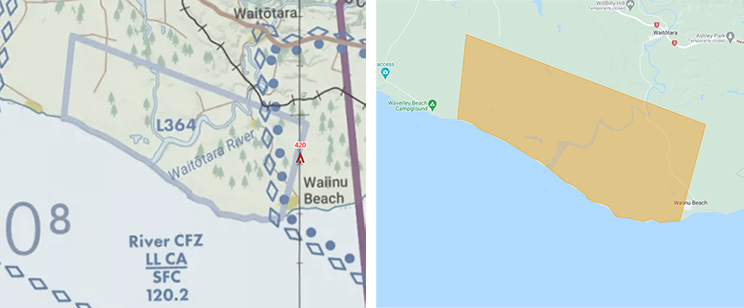
You must never fly in a low flying zone. They are preceded by an 'L' on the Visual Navigation Chart and shown orange on Airshare.
There are also other types of airspace where flying is restricted unless you fulfill certain requirements:
Within 4km of all aerodromes, you must:
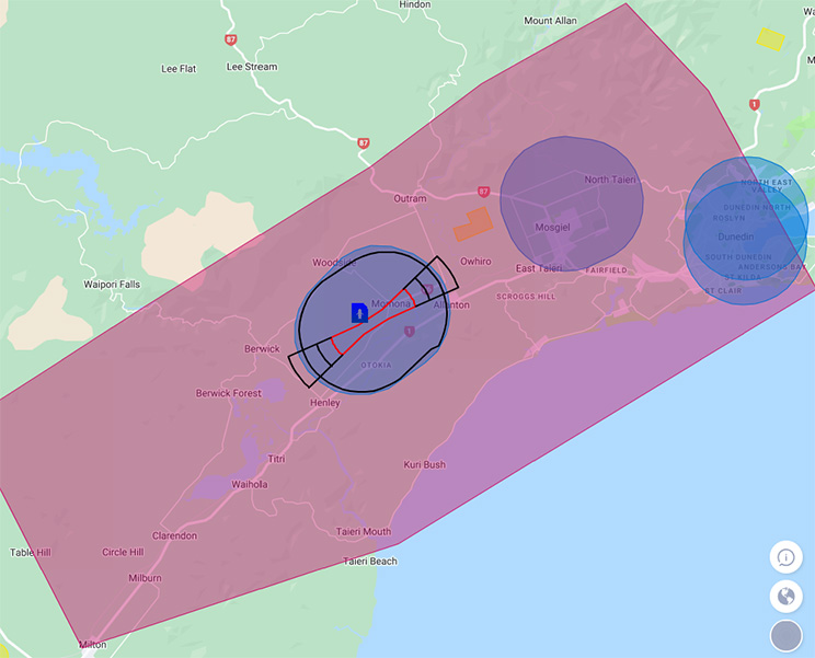
For major aerodromes located within controlled airspace, you must:
These aerodromes are found roughly at the centre of a Control Zone, and are shown on AirShare with additional red and black lines.
The example below is Dunedin Airport in a screenshot from AirShare.
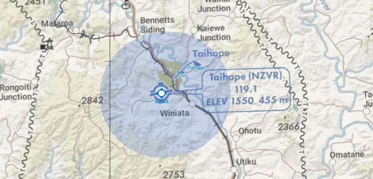
For aerodromes where 4km is wholly in uncontrolled airspace, you must:
The example below is Taihape Aerodrome - a screenshot from the Visual Navigation Chart available from FlightAdvisor.
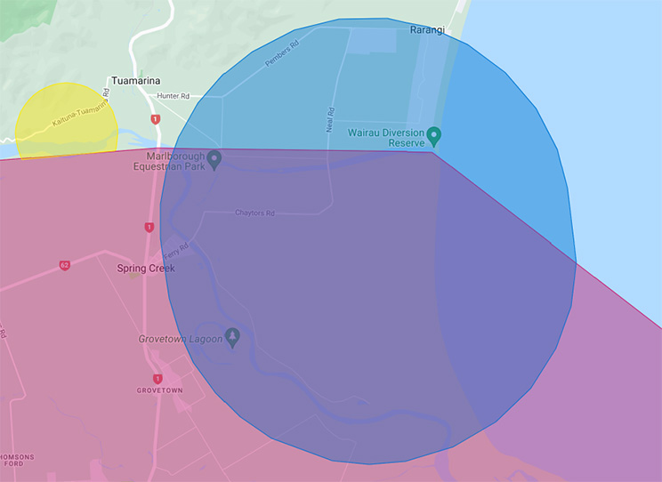
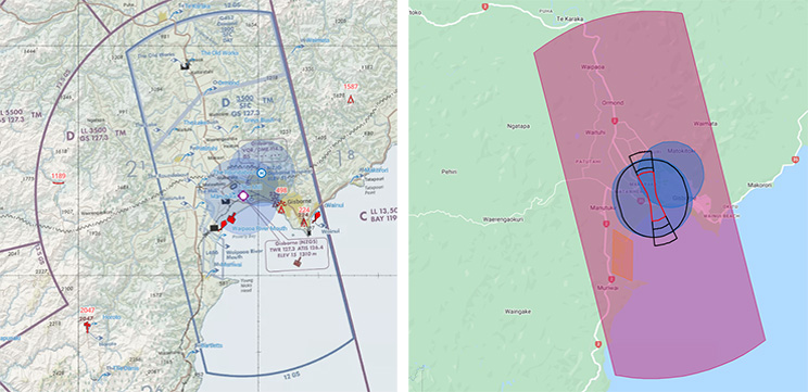
For aerodromes where 4km is wholly or partially within controlled airspace, you must:
These 4km zones are found within or partially within the Control Zone, but not at the centre of the Control Zone. They don’t have additional red and black lines on AirShare.
The example below is Cloudy Bay Aerodrome in a screenshot from AirShare.
For aerodromes where 4km zones overlap, you must:
The example below is Te Kuiti Aerodrome and Te Kuiti Hospital - a screenshot from the Visual Navigation Chart available from FlightAdvisor.
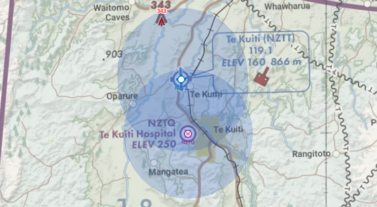
Alternatively, you can operate shielded with a barrier which removes the above requirements.
Control Zones are specific areas of airspace surrounding an aerodrome. They are designated as controlled airspace because they experience high traffic volume and follow specific traffic patterns, which necessitate the presence of air traffic control services. These zones are typically found near major airports that handle regular passenger flights. It's worth noting that these controlled airspace areas can extend farther from the airport than you might expect. You are not permitted to fly non-shielded without consent from Air Traffic Control.
In the examples below, you can see they are the red areas on AirShare and have a large blue C or D and blue outline on the Visual Navigation Chart.
What does it mean to fly shielded?
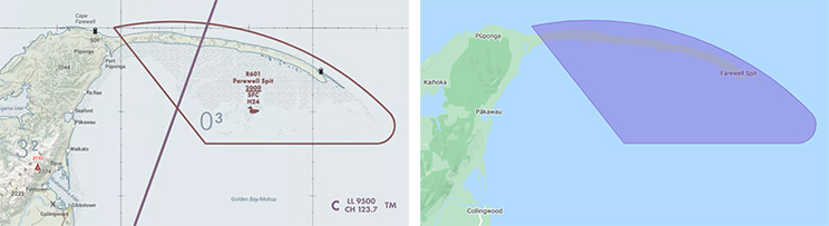
Restricted areas are typically designated as wildlife conservation areas, although there can be other reasons for their establishment as well. It is strictly prohibited to fly in these areas without obtaining consent from the responsible authority that oversees the management of the area.
In the examples below, you can see they are preceded by an 'R' on the Visual Navigation Chart and shown as purple on Airshare.
It is strictly prohibited to fly in these areas without consent from the military organisation that controls the area.
In the examples below, you can see they are preceded by an 'M' on the Visual Navigation Chart and shown green on Airshare.
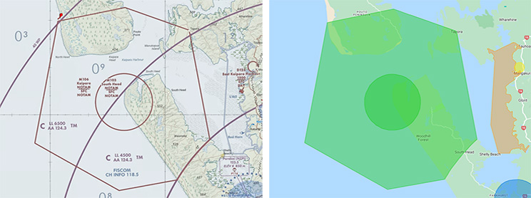
Many Military areas are activated by NOTAM.
See the Where can you fly section for details on how to obtain approvals, and how to view NOTAM.
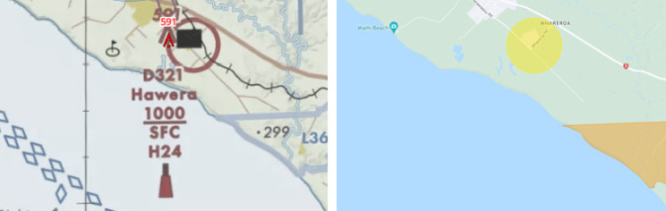
You are allowed to fly in Danger Areas, but it's important to consider the potential hazards associated with them. The most common hazards you may encounter in these areas include firearms, demolition activities, model aircraft, and gas emissions.
In the examples below, you can see they are preceded by a D on the Visual Navigation Chart and shown yellow on Airshare.
Learn more about the rules - Intro to Part 101 rules for unmanned aircraft
Please consider investing in your own knowledge and skills by undertaking a drone pilot course.
If you have any questions about drones, use our contact form, or email rpas@caa.govt.nz